Bomi County
Pronunciation: bum-me |
|||
| Established | Part of Gola Kingdoms 1964: Bomi Territory Mar 19, 1984: Bomi County |
Capital | Tubmanburg (Bomi Hills) |
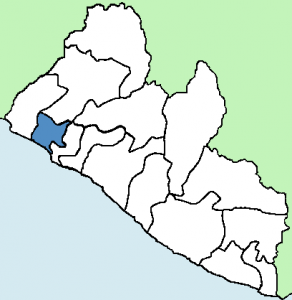
| Location | South West | Area | 757 sq mi |
| Population | 84,119 (2.4%) | Population Density | 111 |
| Tribes | Gola 36%, Dey 23%, Kpelle 21%, Vai 8%, Other 12% | Religion | Christian 40%, Muslim 60%, Traditional N/A |
| Administrative Districts | Dewien, Klay, Senjeh, Suehn Mecca | Electoral Districts | 3 |
The Bomi region is home to the Gola tribe, and referenced as Gola Country in early historical texts. The county’s name means ‘Light’ in the Gola language. There are also Dey, Kpelle, Mandingo, Vai and other tribes residing in Bomi County. Most inhabitants engage in subsistence agriculture.
Per the 2008 census, Bomi had 2 percent of the land area of Liberia and 2.4 percent of the total population. The county had a moderate population density of 111 people per square miles, and a total of 20,508 households, which was approximately 3.1 percent of the Liberian household population.
-LISGIS
Prior to being called Tubmanburg, the capital of the region was called Bomi Hills, the location of Liberia’s first iron ore concession. Iron ore mining in Bomi Hills started in the 1950s, and contributed to Liberia being Africa’s largest, and the world’s third largest iron ore exporter in the 1960’s and 1970’s. Iron ore mining in Bomi Hills ended in 1977. Bomi is also known for rubber export from the Sime Darby (formerly Guthrie) Plantation.
During the Tubman administration’s restructuring of Liberia in 1963, Bomi became a territory under Montserrado County. At the celebration of his seventy-sixth birthday in Bomi Hills, the city was renamed Tubmanburg, in honor of the President. Tubman’s era began the practice of Liberians bestowing many accolades and erecting monuments in honor of the president. The capital is still popularly called Bomi Hills.
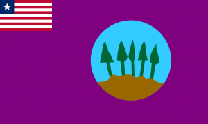
In 1983, it was proposed that the Bomi Territory be annexed from Montserrado County and become Bomi County. Upon approval, Bomi became a county on March 19, 1984 under the Doe administration. The Bomi County County Development Agenda (CDA) of 2008 describes the county flag as showing: “a rich, fertile land crisscrossed with rolling hills, with trees in the background. The hills represent the rich iron ore, while the trees depict the fertility of the soil” (Bomi CDA, 2008).
In spite of large iron ore production in the past, as well as other resources, Bomi is still underdeveloped like most of Liberia. It lacks basic amenities and a majority of its residents live in poverty.
Sources
2008 Census Atlas. Liberia Institute of Statistics and Geo-Information Services (LISGIS). Republic of Liberia. Sep. 2011. Web.
Bomi County Development Agenda. County Development Committee. Emansion. 2008. Web.
Bomi County Profile. The Liberia Institute for Statistics and Geo-Information Services (LISGIS). Republic of Liberia. Web.
Ciment, James. Another America : the Story of Liberia and the Former Slaves Who Ruled It. 1st ed. New York: Hill and Wang, 2013. Print.
Household Income and Expenditure Survey 2016 Statistical Abstract. Liberia Institute of Statistics & Geo-Information Services (LISGIS). Aug. 2017. Web.
Kraaij, Van Der. The Grain Coast, Malaguetta Coast or Pepper Coast before 1822. Liberia Past and Present. Web.
Law, Gwillim. Counties of Liberia. Statoids. Web.
Legislature of Liberia. Web.
Liberia Development Information Gateway. County Development Agendas. Web.
Overview of Bong County. Ministry of Internal Affairs. Republic of Liberia. Web.
Statistical Bulletin. Volume 3. No 1. Liberia Institute of Statistics & Geo-Information Services. Republic of Liberia. Dec. 2011. Web.
Wreh, Tuan. The Love of Liberty : The Rule of President William V. S. Tubman in Liberia, 1944-1971. London: C. Hurst . 1976. Print.
Views: 511


February 3, 2022 @
From Grand bassa