Source: Wikimedia Commons
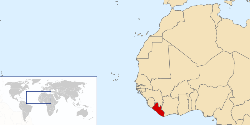
The Republic of Liberia is a small country located in the bulge of the West African Coast. It is bordered by Sierra Leone, Guinea, the Ivory Coast and the Atlantic Ocean. This land is rich in resources like iron ore, timber and rubber. It has vast vegetation and contains approximately 42% of the Upper Guinea Forest.
Established by freed slaves from the United States, Liberia gained her independence more than 170 years ago. The Liberian population comprises mainly Native Liberians with a small fraction of the descendants of the freed slaves from the Americas and recaptured slaves rescued from slave vessels on the Atlantic.
Due to numerous decades of government mismanagement and a 14-year civil war, Liberia remains underdeveloped. It relies on foreign aid, and about 64% of its people live in poverty.
IndependenceJuly 26, 1847
Capital CityMonrovia
Total Area43,000 sq mi
Population4.7 million
Official LanguageEnglish
CurrencyLiberian Dollar (LD) & US Dollar (US)

Photo Credit: www.slon.pics

Photo Credit: Wikimedia Commons
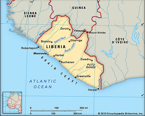
Photo Credit: Encyclopedia Britannica
Geography
| Location | Bulge of the West African Coast. Bordered by Sierra Leone (west), Guinea (north), the Ivory Coast (east) and the Atlantic Ocean (south) |
| Geographic Coordinates | 6 30 N, 9 30 W |
| Administrative Regions | Fifteen counties:
 Base Map: Wikimedia Commons Bomi, Bong, Gbarpolu, Grand Bassa, Grand Cape Mount, Grand Gedeh, Grand Kru, Lofa, Margibi, Maryland, Montserrado, Nimba, River Cess, River Gee, Sinoe |
| Total area | 43,000 sq mi; 111,369 sq km 104th in the world Land: 96,320 sq km Water: 15,049 sq km |
| Coastline | 579 km, Characterized by lagoons, mangrove swamps and sandy beaches |
| Climate | Tropical, hot and humid Two seasons, dry and rainy |
| Elevation extremes | Lowest point: Atlantic Ocean, 0m Highest point: Mt Wuteve, 1,380m, Lofa County |
| Terrain | Flat coastal lowlands, rising to the rolling hills, plateaus and low mountains, and the interior highlands |
| Natural resources | Iron ore, timber, diamonds, gold, rubber |
People
4.7 million (2018 est.)
Tribes/Ethnic Groups
- 3 major ethnolinguistic groups comprising 16 Native Liberian tribes
- Descendants of the freed slaves from the Americas
- Descendants of recaptured/rescued slaves from slave ships on the Atlantic (people from the Congo and other areas on the African Coast)
Note: The 2nd and 3rd groups are commonly called Congo
Population by Tribe
Languages
- 3 ethniclinguistic groups (Kwa, Mel and Mende) comprising the 16 major languages of the Liberian tribes
| Kwa (Kru) | Mel (Atlantic) | Mende |
| Bassa, Belle, Dey, Grebo, Krahn, Kru | Gola, Kissi | Gbande, Gio, Kpelle, Lorma, Mandingo, Mano, Mende, Vai |
- English
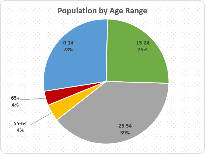
Age Structure
Data from 2017 est. showing population by age range. Over half of the Liberian population is made up of children and young adults, making the dependency ratio very high.
Dependency Ratio
83.2
Median Age
17.8
Sex Ratio
0.99 male/female
Population Growth Rate
2.5%
Birth Rate
38.3 births/1,000 population
Mother’s age at first birth
Mean age: 19.2 years
Median age: 25 – 29
Death Rate
7.6 deaths/1,000 population
Infant Mortality Rate
52.2 deaths/1,000 live births
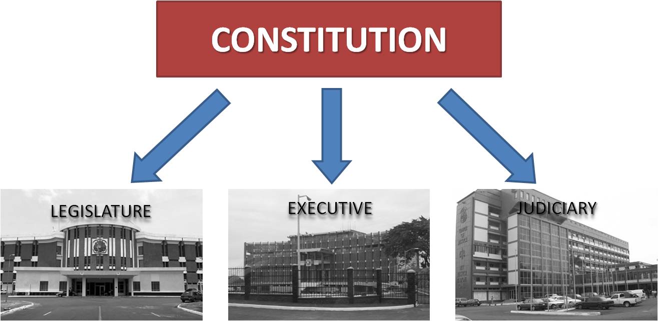
Government
Form of Government
Democratic Republic with Legislative, Executive and Judicial Branches
Legislature
30 Senators
73 Representatives
Executive
Head of State
President George Manneh Weah
Vice President
Jewel Howard-Taylor
Cabinet
Autonomous Agencies
Public Corporations
Judiciary
Supreme Court with 5 Justices
Subordinate Courts
Legal System consists of Statutory and Customary Law
Credit: LiberiaInfo
Economy
| GDP | GDP per capita | GNI per capita | Human Development Index | Poverty Rate |
| US 3.249 Billion | 674.2 | $600 | 0.430 | 64% |
The economy grew by a mere 1.2% in 2018 and the World Bank predicted a negative growth of 1.4% in 2019. Inflation is very high with 1 US dollar being equivalent to more than $200 Liberian dollars.
The Liberian government, from one administration to the next, has been laden with greed, corruption, nepotism, and other actions that enrich its leaders instead of developing the country and its people. Often, a huge portion of the national budget (about 62% for 2018-2019), is allocated towards paying government employees, leaving little funding for other services and development projects.
Liberia’s major exports include timber, rubber, gold, iron ore, diamond, cocoa and coffee. It imports most of its consumer products including rice, various food items, beverages, tobacco, petroleum products, medications, transportation equipment and clothing.
A majority of Liberia lacks electricity, running water, adequate roads and means of transportation and reliable healthcare. It also lack a robust school system, basic nutrition, and many other provisions, facilities, and amenities that would improve the livelihood of its citizens.
Transportation
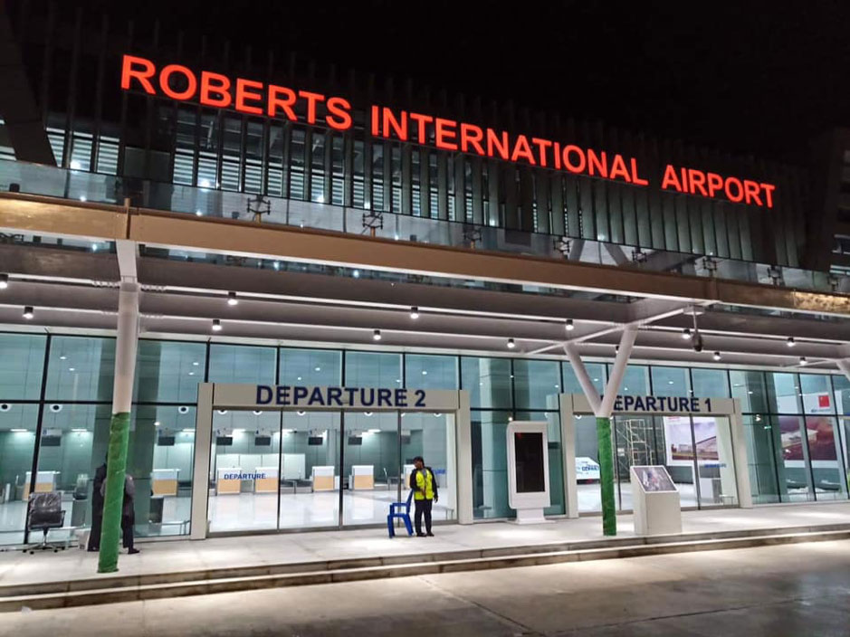
Airports
29 (only 2 have paved runways)
Credit: Front Page Africa
Pipelines
Oil 4km (2013)
Railways
429 km
Roadways
Total: 10,600 km
Paved: 657 km
Unpaved: 9,943 km
Merchant Marine
Total: 3,296
Type: bulk carrier 984, container ship 892, general cargo 120, oil tanker 750, other 550 (2017)
country comparison to the world: 7
Sea Ports
Buchanan, Monrovia, Greenville and Harper
Military and Security
Armed Forces of Liberia (AFL): Army, Coast Guard and Air Force
Military Service
Voluntary service, minimum 18 years of age
Security Expenditures
4.8% of 2018/19 National Budget

Credit: UNMIL Photo/Staton Winter
Sources
About Liberia. United Nations Development Programme. 2012. Web.
Country Comparison: GDP – Per Capita (Ppp). The World Factbook. Central Intelligence Agency. Web.
Legislature Approves 2015/2016 National Budget. Ministry of Information Culture and Tourism. Republic of Liberia. 22 Jul. 2015.
Levy, Patricia, and Michael Spilling. Liberia. New York: Marshall Cavendish Benchmark, 2010. Print.
Ministry of Defense. Republic of Liberia. Web.
Liberia: Overview of corruption and anti-corruption. Transparency International. 7 Sep. 2019.
Liberia Profile. BBC News. 21 May 2013. Web.
Liberia. The World Factbook. Central Intelligence Agency. 24 Sep. 2015. Web.
Liberia. The World Bank. 2015. Web.
Liebenow, J. Liberia : the Quest for Democracy. Bloomington: Indiana University Press, 1987. Print.
National Budget, Fiscal Year 2018/19, Ministry of Finance and Development Planning, Republic of Liberia. 14 Jul. 2018.
National Port Authority of Liberia. Republic of Liberia. Web.
The Executive Mansion. Republic of Liberia. Web.
The Judiciary. Republic of Liberia. Web.
The Legislature. Republic of Liberia. Web.
Visits: 639