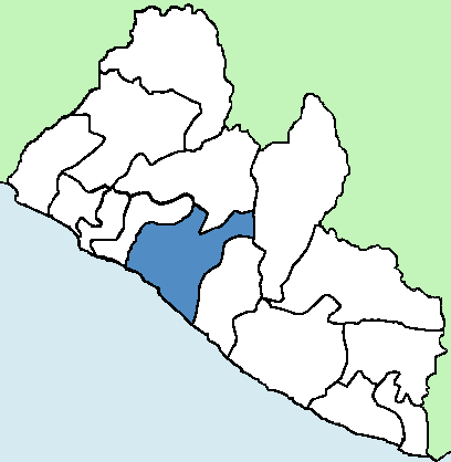
Grand Bassa
Pronunciation: grand bha-saw |
|||
| Established | Bassa Country 1839: Grand Bassa County |
Capital | Gbehzohn Buchanan |
| Location | South Central | Area | 3141.76 sq mi (8.2%) |
| Population | 221,693 (6.4%) | Population Density | 71 |
| Tribes | Bassa 94%, Kpelle 5%, Kissi 1% | Religion | Christian 93%, Muslim 5%, Traditionalist 2% |
| Administrative Districts | Commonwealth, District #1, District #2, District #3, District #4, Neekreen, Owensgrove, St. John River City | Electoral Districts | 5 |
Grand Bassa County is home to the Bassa tribe after which it is named. Bassa land covers parts of Montserrado, Margibi, Grand Bassa and River River Cess Counties. Bassa (pronounced bha-SAW) means Father Stone in the Bassa language. The Bassa tribe occupied this land for centuries before it became a county. Till today, the county and its capital are called Gbehzohn by the Bassa.
The coastal area of this county is mentioned centuries before it became Grand Bassa County with the Normans calling it Petit Dieppe in the 14th century. Sections of the region became Bassa Cove, Bexley and Edina as colonial settlements established by the freed slaves/settlers in the early 1800’s. From this county came Presidents Smith, Gardner, and Cheeseman. Its capital is Buchanan, named after Thomas Buchanan who was Chief Magistrate of Bassa Cove from January 1836 – August 4, 1837; Governor of Mississippi in Africa (currently Sinoe County) from 1838 – 1839 and the first Governor of Liberia from 1839 – 1841.
Along with Montserrado, Grand Bassa became a county by the American Colonization Society (ACS) and settlers when they formed the Commonwealth of Liberia in 1839. This was a conglomeration of the colonial settlements in the Mesurado and Bassa areas to form one unit under the governorship of Thomas Buchanan.
River Cess was a territory under Grand Bassa until it was carved out in 1985. Grand Bassa is currently divided into 5 statutory districts, 9 administrative districts, 11 townships, 3 cities (Buchanan, Edina, and St. John River City) and 45 clans (Grand Bassa CDA, 2008). It has 8.2% of the land area of Liberia. Per the 2008 census, the population was 221,693 (6.4%) with a population density of 71.
The county is well watered, having the Benson, Ilor, St. John, Farmington, Timbo and New Cess Rivers. It has a typical tropical Liberian climate and flat coastal region which is susceptible to erosion. Many residents of Bassa are farmers, cultivating cassava, rice, plantain, palm oil and other crops. Rubber is grown by a small percentage of farmers and small scale fishing is done in Buchanan. Agricultural constraints like the lack of seed and tools, lack of fertilizer and pesticides, insufficient funding and others have kept production at sustenance levels.
Grand Bassa has seen little development since the 1800s and remains in poor shape. The Monrovia-Buchanan road is paved, but traveling within the county is extremely difficult. Like most of Liberia, basic social amenities like safe drinking water, sanitation facilities, hospitals and schools are substandard or completely lacking in some areas.
Credit: Wikipedia
Credit: Wikipedia
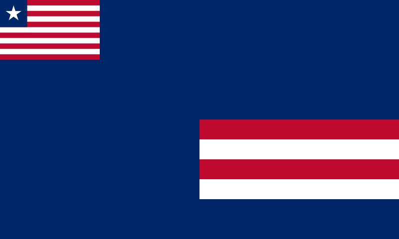
The county’s flag contains the Liberian flag in the top left, a blue field signifying loyalty, and four alternating red and white stripes representing the county’s signatories of the Declaration of Independence; namely, Anthony Gardner, John Day, Ephraim Titler and Amos Herring (Grand Bassa CDA, 2008).
Sources
Cahoon, Ben. Liberia. Worldstatesmen. 2000. Web.
Grand Bassa County Development Agenda. County Development Committee. Republic of Liberia. 2008. Web.
Grand Bassa County Health Plan 2007/2008. Ministry of Health & Social Welfare. Republic of Liberia. Sep. 2007. Web.
Huberich, Charles Henry. The Political and Legislative History of Liberia. New York: Central Book Co., 1947.
Johnston, Harry Hamilton. Liberia. Hutchinson & Co., 1906. Print.
Senate. Legislature of Liberia. N.p., n.d. Web.
Visits: 345